


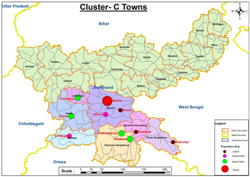
Project 1: Master Plans and Zonal Development Plans of 9 Towns Of Jharkhand
PROJECTS
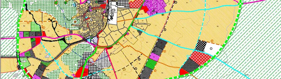
- The project is to prepare Master Plans and Zonal Development Plans of the following towns: Lohardaga, Bundu, Khunti, Gumla, Simdega, Chaibasa, Chakradharpur, Saraikela, Chakulia.
- Master Plan aims to promote sustainable development of the towns by regulating the present and future spatial development envisaged for the horizon year 2040.
- Aim of the Zonal/ Sector Plans is to detail out the broad objectives of the Master Plans at comparatively smaller regions while incorporating the guidelines and proposals by the Master Plans without deviating far from the primary goal of development set by Master Plans.
SCOPE OF WORK:
- Preparation of revenue based existing land use map through ground-truthing of existing development indicating the khasra nos.
- Analysis of existing situation (Physical and Social Infrastructure, Socio-Economic Conditions)
- Detailing of proposed land use plan along with infrastructure plan and formulation of strategies
- Preparation of Draft Master Plans and Zonal Development Plans
- Suggesting amendments in infrastructure/ service plans and appropriate changes in the zoning regulations/ development controls/ density norms
- Stakeholder consultations and workshops
- Incorporating all the amendments suggested by the TPD after considering the objections/ suggestions received from the general public in response to the Public notice.
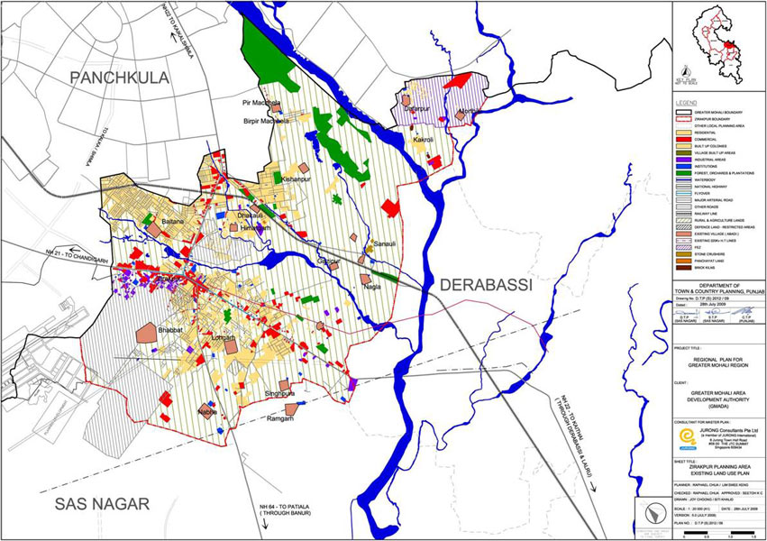
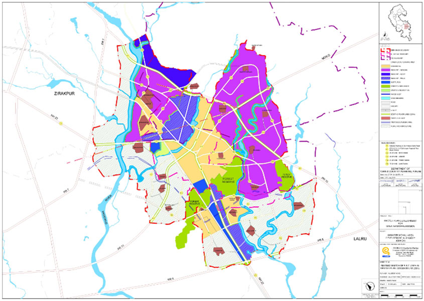
Project 2: Master Plan Of Zirakpur, Dera Bassi
To prepare extensive/ detailed area utilization plans for the already notified Master Plans of the following towns: Zirakpur and Dera Bassi. The project was to promote sustainable development and balanced growth of the towns by regulating the present and future spatial development envisaged for the horizon year.
Objectives are:
- Ensure a well laid out, contiguous, coherent and systematic growth of the Planning Areas
- Improve and provide accessibility to both the urban extensions and the rural areas
- Ensure balanced overall economic and social development of the zones
- Preserve and conserve the natural resources, ecosystems and natural heritage
- Upgrade and augment the required infrastructure for the projected population
Scope:
- Analysis of existing master plan proposals and to come up with recommendations to improve the overall Master Plan
- Verification of revenue based existing land use plan and master plan for proper implementation and ground-truthing of existing development indicating the khasra nos.
- Review of already approved layout plans of different promoters in order to check the congeniality and contiguity and to suggest measures for improvements
- Detailing of proposed land use plan along with traffic and transportation plan and infrastructure plan
- Preparation of Sector/ Zonal Plans and detailed landscape plans
- Suggesting amendments in infrastructure/ service plans and appropriate changes in the zoning regulations/ development controls/ density norms
- Incorporating all the amendments suggested by the TPD after considering the objections/ suggestions received from the general public in response to the Public notice.
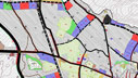
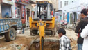
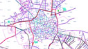
PROJECT IMAGESCLICK IMAGES TO ENLARGE


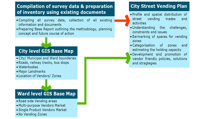
Project 3: Street Vending Plan in 21 Towns of Jharkhand
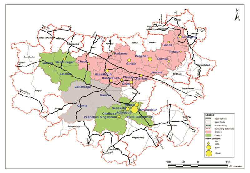
Aim of the project is promotion of sustainable development of the large informal and unorganized workforce in 21 cities in Jharkhand by identifying Street Vendors through detailed field surveys and preparing a Detailed Plan of Action for regulating, relocation and rehabilitation of street vendors, as per the Street Vendors (Protection of Livelihood and Regulation of Street Vending) Act, 2014
Objectives are:
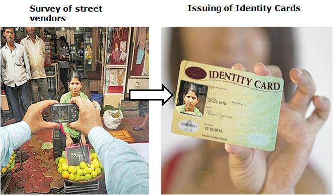
- Survey of street vendors and issue of Identity Cards
- City Level Mapping
- Vendor Location Level Mapping
- Developing MIS and De Duplication Software
- Development of city street vending plans
- Formation of Town Vending Committee
- Preparation of Detailed Implementation Plan for Infrastructure development of vending zones in the city
- Organizing Dissemination Workshop for comments and suggestions
Project 4: Street Vending Plan in Allahabad
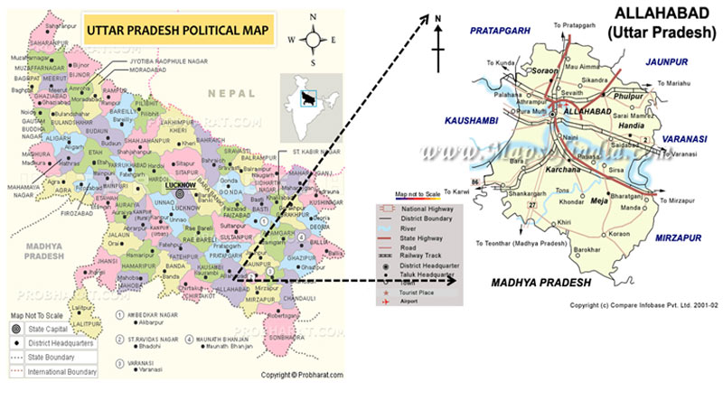
To support Allahabad Nagar Nigam in promotion of sustainable development of the large informal and unorganized workforce in Allahabad by identifying Street Vendors through detailed field surveys and preparing a Detailed Plan of Action for regulating, relocation and rehabilitation of street vendors, as per the support to Urban Street vendors under NULM & Street Vendors (Protection of Livelihood and Regulation of Street Vending) Act, 2014.
Objectives are:
- Survey of street vendors and issue of Identity Cards.
- City Level Mapping and Vendor Location Level Mapping.
- Development of City Vending Plans.
- Formation of Town Vending Committee.
- Development of Management Information System for monitoring purpose after the implementation.
- Preparation of Draft Detailed Infrastructure Plan for Infrastructure Development of vending zones.
Project 5: Street Vending Plan in Kota
To support Kota Municipal Corporation in promotion of sustainable development of the large informal and unorganized workforce in Kota by identifying Street Vendors through detailed field surveys and preparing a Detailed Plan of Action for regulating, relocation and rehabilitation of street vendors, as per the Support to Urban Street vendors under NULM & Street Vendors (Protection of Livelihood and Regulation of Street Vending) Act, 2014
Project 6: Street Vending Plan in Jodhpur.
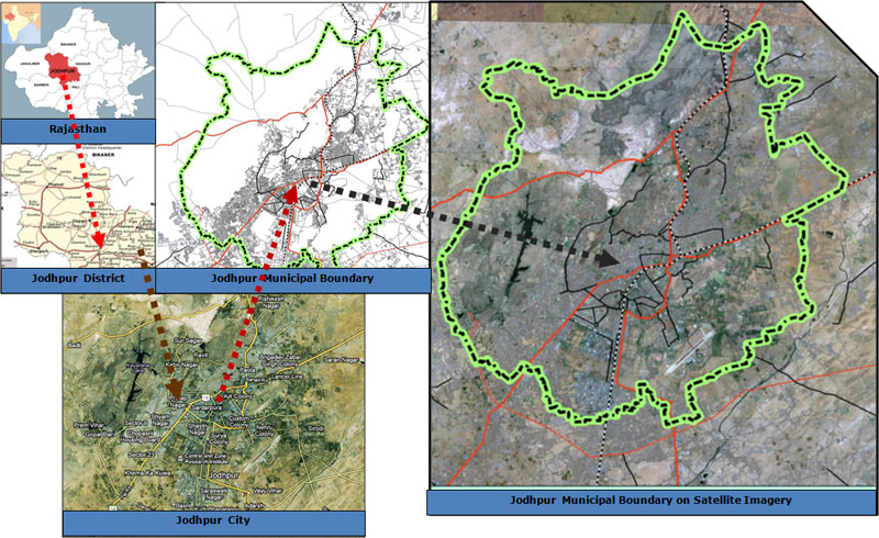
This projects is to address Address the concerns of urban street vendors by facilitating access to suitable spaces for vending, institutional credit, improved skills and social security linkages.
Objectives are:
- Survey of street vendors and issuing of identity cards
- Development of City Vending Plans
- Infrastructure development of vending zones in the city
- Training and Skill Development
- Financial inclusion, Access to credit & Linkages to social security schemes
Components are:
- Survey of street vendors and issuing of identity cards
- Development of city vending plans
- Formulate implementation guidelines
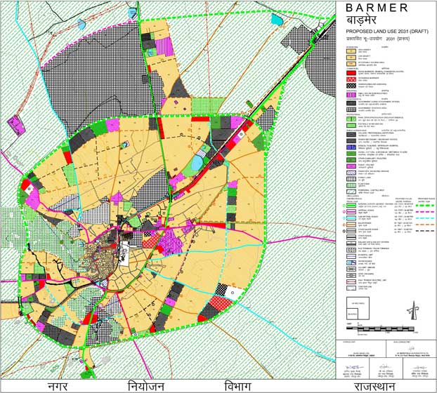
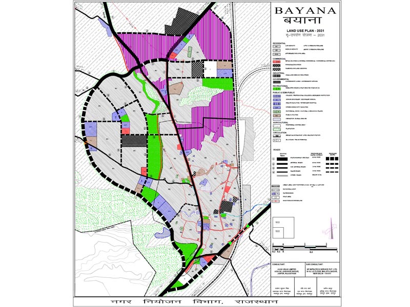
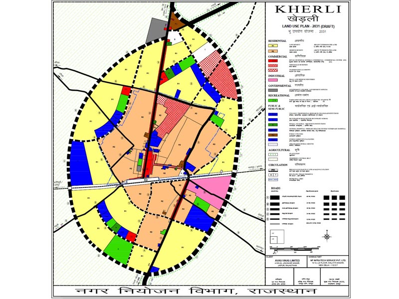
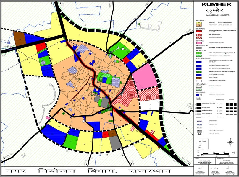
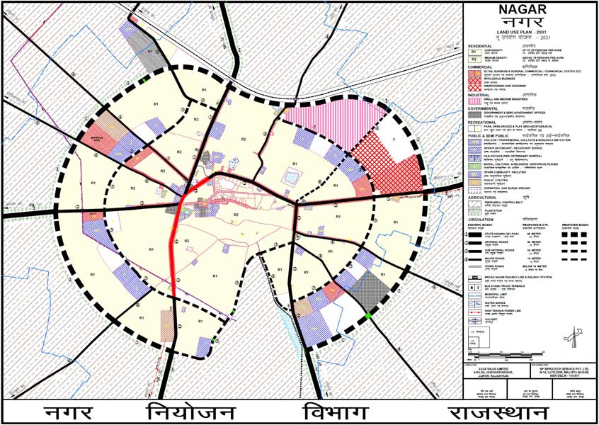
Project 7: Master Plans of Barmer, Kumher, Nadbai, Nagar, Bayana, Kherli, Chaksu, Rajgarh, Bandikui, Kotputli and Fatehpur in Rajasthan
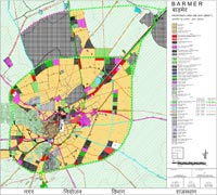 The objective of the projects was to prepare Draft Master Plans for the year 2031 after detailed study of the present conditions for transportation, physical and social infrastructure, housing, etc. The focus was to provide quality urban infrastructure in all the urban centres and the rural areas for improved quality of life by thoughtfully placing the proposed land uses. Points like Environmental sustainability, preservation of ecology and minimal damage due to development, which is inevitable, were also considered.
Services provided by NFIT:
- Preparation of Inception Report and Urban Area Notification Document
- Preparation of Base Maps
- Preparation of existing Land Use Maps
- Conducting of surveys, data gathering and compilation
- Forecasting (Population, infrastructure, housing, transportation, land requirements)
- Assessment of existing conditions and future needs
- Framing of Development proposals
- Preparation of Draft Master Plans and Land Use Plans
Client: Rajasthan Avas Vikas and Infrastructure Ltd, Jaipur, Rajasthan
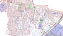
PROJECT IMAGESCLICK IMAGES TO ENLARGE


Project 8: Master Plans of Reasi, Ramban and Akhnoor in Jammu district of J&K
The objectives of the projects are:
- Holistic development of industrial and transportation infrastructure to facilitate appropriate activity dynamics
- Setting up of trade centres to give the towns the impetus as growth centres for its hinterland
- Augmentation and upgradation of the basic amenities and infrastructure (Physical and social)
- Improvement of the living environment through the provision of better sewerage and drainage facilities and introduction of solid waste management
- Delineation of the various land use areas in tune with the land suitability analysis and desired growth pattern
- Identification of potential frontiers of town development
- Development of business and transit centres for promotion of trans-boundary trade.
Services provided by NFIT:
- Preparation of Inception Report and Urban Area Notification Document
- Preparation of Base Maps
- Preparation of existing Land Use Maps
- Conducting of surveys, data gathering and compilation
- Forecasting (Population, infrastructure, housing, transportation, land requirements)
- Assessment of existing conditions and future needs
- Framing of Development proposals
- Preparation of Draft Master Plans and Land Use Plans
Client: Town Planning Organization, Jammu, J&K
PROJECT IMAGESCLICK IMAGES TO ENLARGE

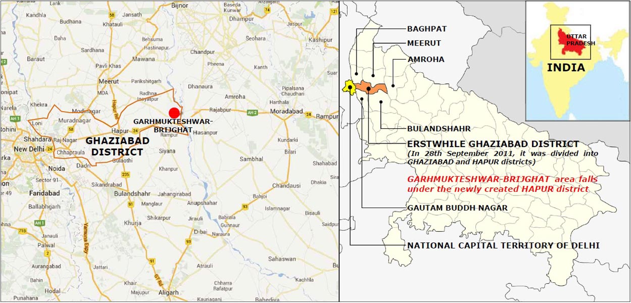
Project 9: Zonal Development Plans of Garhmukteshwar-Brijghat Master Plan 2021 in Uttar Pradesh
The aim of preparation of ZDPs is to improve the quality of life of residents by:
- Augmenting regional connectivity;
- Upgrading physical and social infrastructure; and
- Promoting sustainable development.
The main objectives of the project are to:
- Improve accessibility/ connectivity with both the urban extension and the rural areas
- Ensure that different land use requirements of the community are met in a sustainable way
- Upgrade infrastructure (Both physical and social)
- Promote sustainable development by preserving natural resources and eco-system of the region
- Shape a tourist attraction point
- Develop adequate parking area facilities nearby Brijghat (Owing to its religious tourism potential)
Client: Hapur-Pilkhuwa Development Authority, Hapur, Uttar Pradesh
PROJECT IMAGESCLICK IMAGES TO ENLARGE
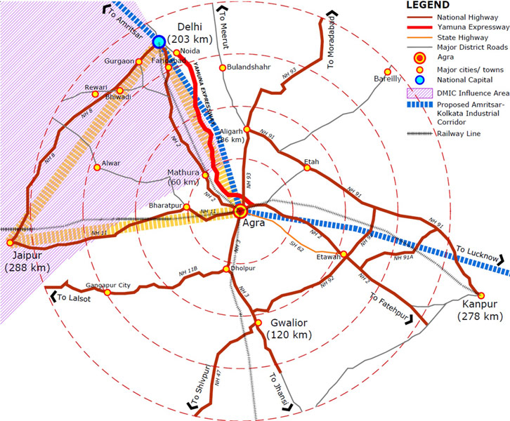
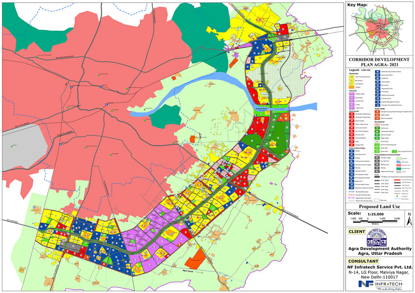
Project 10: Corridor Development Plan of the proposed Agra Inner Ring Road joining NH 2 and NH 3
A Corridor Development Plan is a detailed plan for the area adjoining to and lying in the periphery of a Corridor, conceived and prepared within the framework of a Master Plan, and would contain the proposals for the various land uses, roads and streets, parks and open spaces, community facilities, services and public utilities, etc. with a view to ensure planned and orderly development pursuant to the construction of the Corridor.
The primary aim of the Corridor Development along the Inner Ring Road of Agra is to develop a Special Investment Region (Hi-Tech cluster) driving sustainable economic growth while keeping in mind the importance of natural environment, history and legacy of the place, along with tourist infrastructure to increase the duration of stay of international and domestic tourists
The scope of work includes:
- Preparation of Base Map showing all buildings, roads, railway lines, water bodies, culverts, bridges, high/low tension lines, drainage lines, layouts, parks, playgrounds, wetlands, etc. using high resolution latest satellite image (Quick Bird or Cartosat II or 0.60 meter or more resolution not older than six months) or through physical survey using Total Station.
- Superimposition of base map on village sajra plans.
- Preparation of existing land use map along with analysis of land uses i.e. (residential, commercial, industrial, community facilities and civic amenities, parks and playgrounds, traffic and transportation, water bodies, etc.) showing all natural/man made nalla, rainwater drains (more than 1.00 meter wide), tanks, existing circulation system showing all highways, arterial roads, collector roads, minor roads (more than 2.00 meter wide), bus and truck terminals, railway lines, etc. on the basis of land use survey using land use classification as given in the Master Plan.
- Superimposition of Master Plan proposals on the existing land use map.
- Existing land use analysis indicating and highlighting the deviations/violations of Master Plan land uses, if any.
- Availability of existing infrastructure facilities, e.g. water supply, drainage, sewerage and electricity, etc. and assessment of future requirements.
- Delineation of environmentally sensitive, heritage of important areas, if any.
- Policy and strategy framework for development of the corridor.
- Corridor Development Plan proposals with detailed analysis and maps.
- Implementation Schedule.
- Superimposition of the approved Corridor Development Plan on village Sajra Plan.
Client: Agra Development Authority, Agra, Uttar Pradesh
PROJECT IMAGESCLICK IMAGES TO ENLARGE
Project 11: Conducting physical survey of various villages within Mussoorie-Dehradun Development Authority area in Uttaranchal
The physical survey of different villages adjoining Dehradun and Mussoorie city covering approximately 4000hectare of area for preparing the master plan needs to be conducted.
The scope of work includes:
- Preparation of Base Map showing contour at 5mtr interval, alltypes of building use, roads, water bodies, culverts, bridges,high/low tension lines, drainage lines, layouts, parks, playgrounds,wetland, forest etc. using high resolution latest image and updatingthe same through physical survey using Total Station.
- Rectification and geo-referencing using DGPS control survey.
- Digitisation of Sajra plans of the surveyed areas and its mosaicmap superimposed on the base map.
- Interpretation of satellite imagery with ground verification toprepare the digital base map and existing land use map in GISformat.
- Delineation of environmentally sensitive, heritage or importantareas, if any
Client: Mussoorie Dehradun Development Authority, Dehradun, Uttaranchal


